Neighborhoods of Rio De Janeiro: Difference between revisions
No edit summary |
|||
| Line 79: | Line 79: | ||
The highest hill in Rio is Pedra Branca peak (Pico da Pedra Branca), in Barra da Tijuca region, and one of the most famous hills in the city is the 842 metres (2,762 ft) high Pedra da Gávea (Crow's nest Rock) near South Zone. On the top of its summit is a huge rock formation (some, such as Erich von Däniken in his 1973 book, "In Search of Ancient Gods", claim it to be a sculpture) resembling a sphinx-like, bearded head that is visible for many kilometers around. | The highest hill in Rio is Pedra Branca peak (Pico da Pedra Branca), in Barra da Tijuca region, and one of the most famous hills in the city is the 842 metres (2,762 ft) high Pedra da Gávea (Crow's nest Rock) near South Zone. On the top of its summit is a huge rock formation (some, such as Erich von Däniken in his 1973 book, "In Search of Ancient Gods", claim it to be a sculpture) resembling a sphinx-like, bearded head that is visible for many kilometers around. | ||
This is the area of the City that will hold most of the sports venues and competitions during the 2016 Summer Olympic Games. It will be home to the Olympic Village, Olympic Beach, and Olympic Park as well. | This is the area of the City that will hold most of the sports venues and competitions during the 2016 Summer Olympic Games. It will be home to the Olympic Village, Olympic Beach, and Olympic Park as well. [https://en.wikipedia.org/wiki/2016_Summer_Olympics] | ||
==== '''Northern Region -- Campo Grande / Santa Cruz''' ==== | ==== '''Northern Region -- Campo Grande / Santa Cruz''' ==== | ||
Revision as of 11:12, 23 August 2016
Centro
Centro is the historic core of the city, as well as its financial center. Sites of interest include the Paço Imperial, built during colonial times to serve as a residence for the Portuguese governors of Brazil; many historic churches, such as the Candelária Church, (the former cathedral), Sao Jose, Santa Lucia, Nossa Senhora do Carmo, Santa Rita, San Francisco de Paula, and the monasteries of Santo Antonio and Sao Bento. The Centro also houses the modern concrete Rio de Janeiro Cathedral. Around the Cinelândia square, there are several landmarks of the Belle Époque of Rio, such as the Municipal Theatre and the National Library building. Among its several museums, the Museu Nacional de Belas Artes (National Museum of Fine Arts) and the Museu Histórico Nacional (National Historical Museum) are the most important. Other important historical attractions in central Rio include its Passeio Público, an 18th-century public garden. Major streets include Avenida Rio Branco and Avenida Vargas, both constructed, in 1906 and 1942 respectively, by destroying large swaths of the colonial city. A number of colonial streets, such as Rua do Ouvidor and Uruguayana, have long been pedestrian spaces, and the popular Saara shopping district has been pedestrianized more recently.
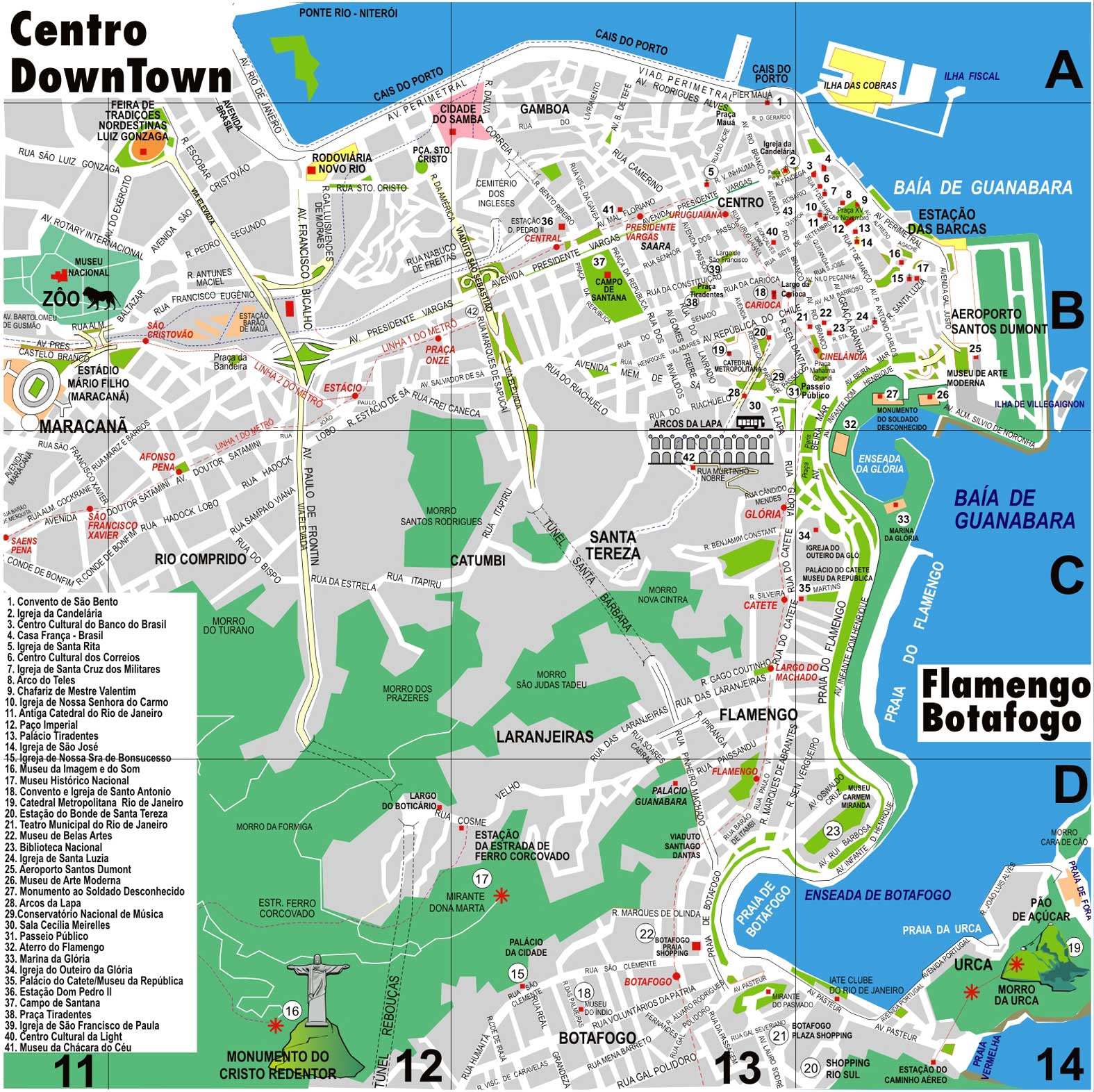
Places of Interest
- -- Avenida Rio Branco
- -- Avenida Vargas
- -- Candelária Church
- -- Cinelândia Square
- -- Municipal Theatre
- -- Museu Histórico Nacional -- National Historical Museum
- -- Museu Nacional de Belas Artes -- National Museum of Fine Arts
- -- National Library
- -- Paço Imperial
- -- Passeio Público -- An 18th-century public garden.
- -- Rio de Janeiro Cathedral
- -- Rua do Ouvidor
- -- Rue Uruguayana
- -- Saara -- A popular shopping district.
Zona Sul
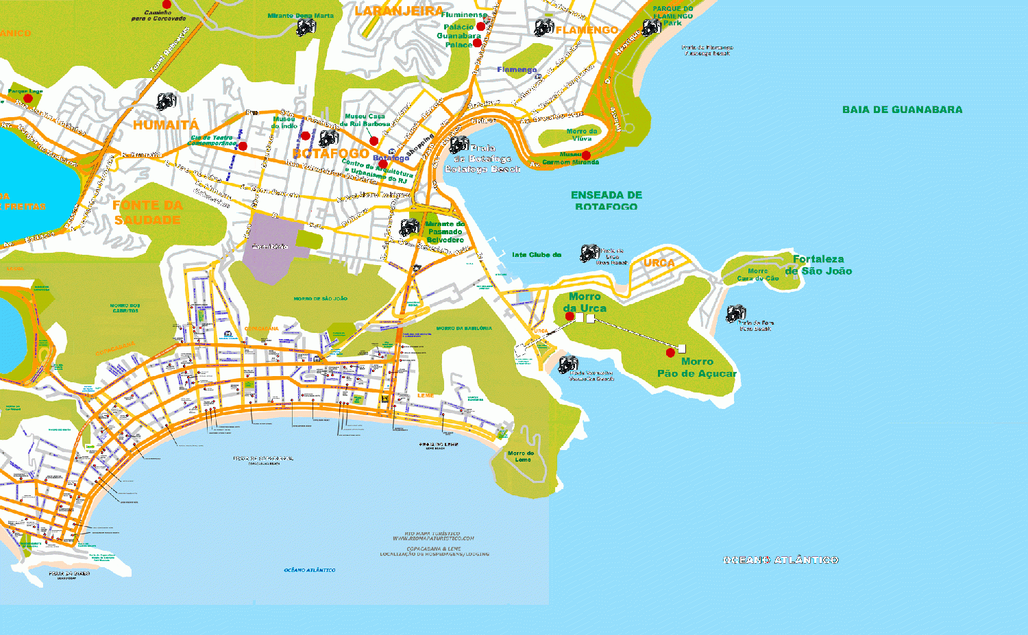
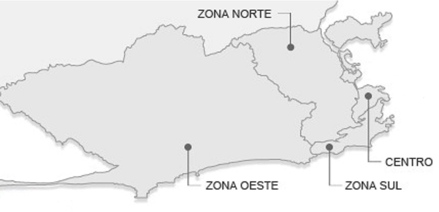
The South Zone of Rio de Janeiro is composed of several districts, among which are São Conrado, Leblon, Ipanema, Arpoador, Copacabana, and Leme, which compose Rio's famous Atlantic beach coastline. Other districts in the South Zone are Glória, Catete, Flamengo, Botafogo, and Urca, which border Guanabara Bay and Santa Teresa, Cosme Velho, Laranjeiras, Humaitá, Lagoa, Jardim Botânico, and Gávea.
It is the wealthiest part of the city and the best known overseas; the neighborhood of Leblon in particular has the most expensive real estate in all of South America.
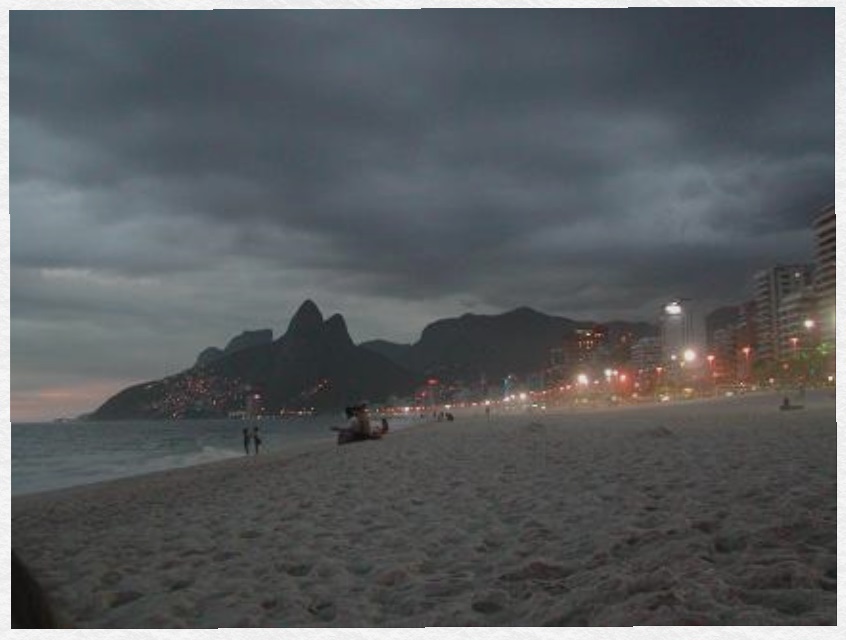
The neighbourhood of Copacabana beach hosts one of the world's most spectacular New Year's Eve parties ("Reveillon"), as more than two million revelers crowd onto the sands to watch the fireworks display. As of 2001, the fireworks have been launched from boats, to improve the safety of the event. To the north of Leme, and at the entrance to Guanabara Bay, is the district of Urca and the Sugarloaf Mountain ('Pão de Açúcar'), whose name describes the famous mountain rising out of the sea. The summit can be reached via a two-stage cable car trip from Praia Vermelha, with the intermediate stop on Morro da Urca. It offers views second only to Corcovado mountain.
Hang gliding is a popular activity on the Pedra Bonita (literally, "Beautiful Rock"). After a short flight, gliders land on the Praia do Pepino (Pepino, or "cucumber", Beach) in São Conrado.
Since 1961, the Tijuca National Park (Parque Nacional da Tijuca), the largest city-surrounded urban forest and the second largest urban forest in the world, has been a National Park. The largest urban forest in the world is the Floresta da Pedra Branca (White Rock Forest), which is also located in the West Zone of Rio de Janeiro. The Pontifical Catholic University of Rio (Pontifícia Universidade Católica do Rio de Janeiro or PUC-Rio), Brazil's top private university, is located at the edge of the forest, in the Gávea district. The 1984 film "Blame It on Rio" was filmed nearby, with the rental house used by the story's characters sitting at the edge of the forest on a mountain overlooking the famous beaches.
Zona Norte
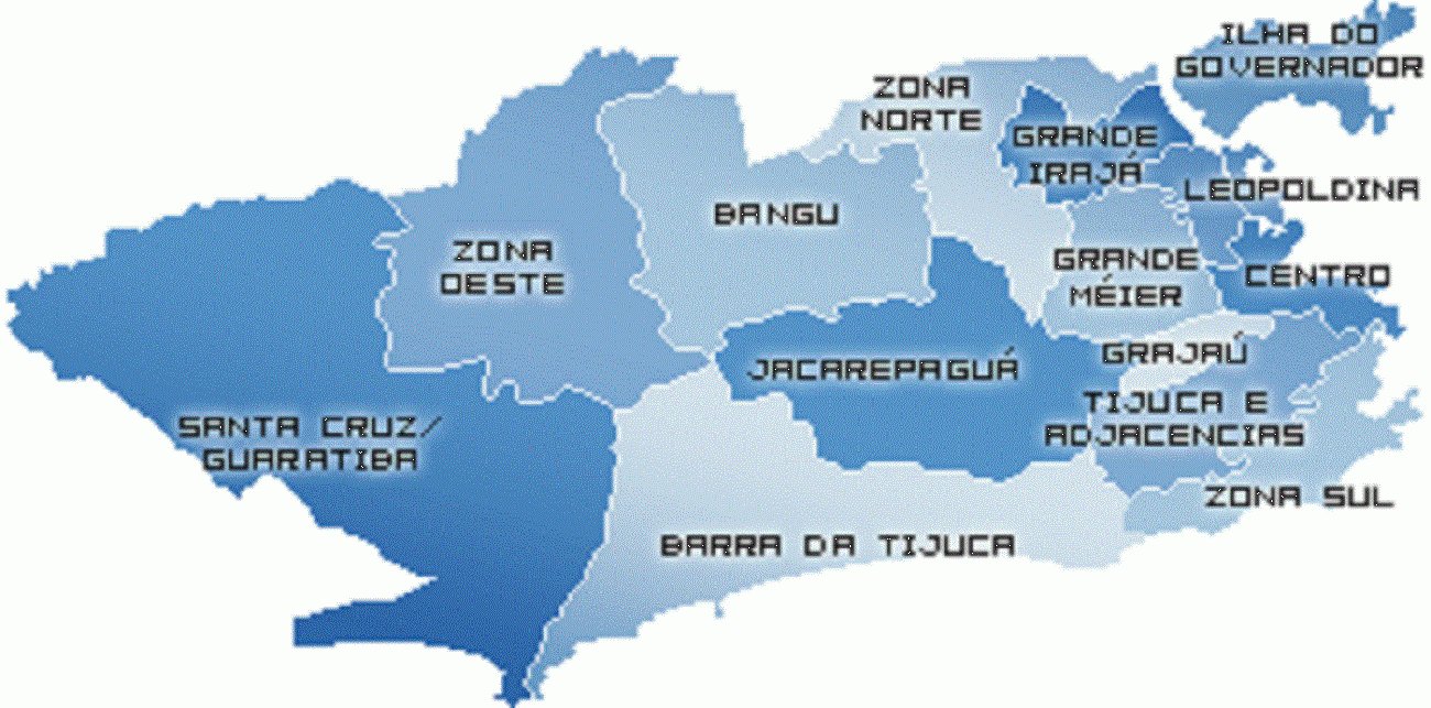
The North Zone begins at Grande Tijuca (the middle class residential and commercial bairro of Tijuca and its surrounding neighborhoods and favelas), just west of the city center, and sprawls for miles inland until Baixada Fluminense and the city's Northwest.
This region is home to the Maracanã stadium (located in Grande Tijuca), once the world's highest capacity football (soccer) venue, able to hold nearly 199,000 people, as it did the World Cup final of 1950. In modern times its capacity has been reduced to conform with modern safety regulations and the stadium has introduced seating for all fans. Currently undergoing reconstruction, it has now the capacity for 90,000 fans; it will eventually hold around 80,000 people. Maracanã was site for the Opening and Closing Ceremonies and football/soccer competition of the 2007 Pan American Games, and will host the final match of 2014 FIFA World Cup and the Opening and Closing Ceremonies and football matches of the 2016 Summer Olympics. Tijuca Forest in the city.
Besides Maracanã, the North Zone of Rio also holds other tourist and historical attractions, such as 'Manguinhos', the home of Instituto Oswaldo Cruz, a centenarian biomedical research institution with a main building fashioned like a Moorish palace, and the beautiful Quinta da Boa Vista, the park where the historic Imperial Palace is located. Nowadays, the palace hosts the National Museum, specializing in Natural History, Archaeology, and Ethnology.
The International Airport of Rio de Janeiro (Galeão – Antônio Carlos Jobim International Airport, named after the famous Brazilian musician Antônio Carlos Jobim), the main campus of the Federal University of Rio de Janeiro at the Fundão Island, and the State University of Rio de Janeiro, in Maracanã, are also located in the Northern part of Rio.
This region is also home to most of the samba schools of Rio de Janeiro such as Mangueira, Salgueiro, Império Serrano, Unidos da Tijuca, among others. Some of the main neighborhoods of Rio's North Zone are Tijuca, which shares the Tijuca Rainforest with the South and Southwest Zones; Água Santa, Vila Isabel, Méier, São Cristovão, Madureira, Penha, Manguinhos, Fundão, among others.
Many of the Rio de Janeiro's roughly 1000 shantytowns, or favelas, which makes it resembling many other cities in underdeveloped and developing countries, are located in Zona Norte.
Zona Oeste
The West Zone of the city of Rio de Janeiro makes up about 50% of the city area. It has two areas with very different characteristics: the southern part of West Zone is a rich area, considered an extension of the South Zone. The northern part of the West Zone is a suburb, considered an extension of the North Zone.
Southern Region -- Barra da Tijuca
This area is the most recently modernized region of Rio de Janeiro. It includes Barra da Tijuca, Recreio dos Bandeirantes, Vargem Grande, Vargem Pequena, Grumari, Jacarepaguá as well minor neighbourhoods close to those cited here. There is a clear social contrast between this area and the Campo Grande/Santa Cruz area. Nevertheless, this area has its own favelas, such as Cidade de Deus, outlying the middle and upper class areas.
Westwards from the older zones of Rio, Barra da Tijuca is a flat complex of barrier islands of formerly undeveloped coastal land, which constantly experience new constructions and developments. It remains an area of accelerated growth, attracting some of the richer sectors of the population as well as luxury companies. High rise flats and sprawling shopping centers give the area a far more American feel than the crowded city centre.
The urban planning of the area, made in the late 1960s, resembles that of United States suburbs, through mixing zones of single-family houses with residential skyscrapers. The beaches of Barra da Tijuca are also popular with the city's residents. Barra da Tijuca is the home of Pan-American Village built for the 2007 Pan American Games.
The highest hill in Rio is Pedra Branca peak (Pico da Pedra Branca), in Barra da Tijuca region, and one of the most famous hills in the city is the 842 metres (2,762 ft) high Pedra da Gávea (Crow's nest Rock) near South Zone. On the top of its summit is a huge rock formation (some, such as Erich von Däniken in his 1973 book, "In Search of Ancient Gods", claim it to be a sculpture) resembling a sphinx-like, bearded head that is visible for many kilometers around.
This is the area of the City that will hold most of the sports venues and competitions during the 2016 Summer Olympic Games. It will be home to the Olympic Village, Olympic Beach, and Olympic Park as well. [1]
Northern Region -- Campo Grande / Santa Cruz
This area is separated from the Barra da Tijuca by the Maciço da Pedra Branca and the Serra da Grota Funda. It has exhibited economic growth, mainly in the Campo Grande neighborhood. New industrial enterprises are being built in contemporarily lower and lower middle class residential Santa Cruz, one of the largest and most populous Rio de Janeiro's neighborhoods, most notably Companhia Siderúrgica do Atlântico (CSA), a new steel mill with its own private docks on Sepetiba Bay, planned to be South America's largest steel works. A tunnel called Túnel da Grota Funda, projected to open to traffic until May 2012, will diminish the time of access to the region from other areas of Rio de Janeiro and create a public transit facility between Barra da Tijuca and Santa Cruz.
South Zone
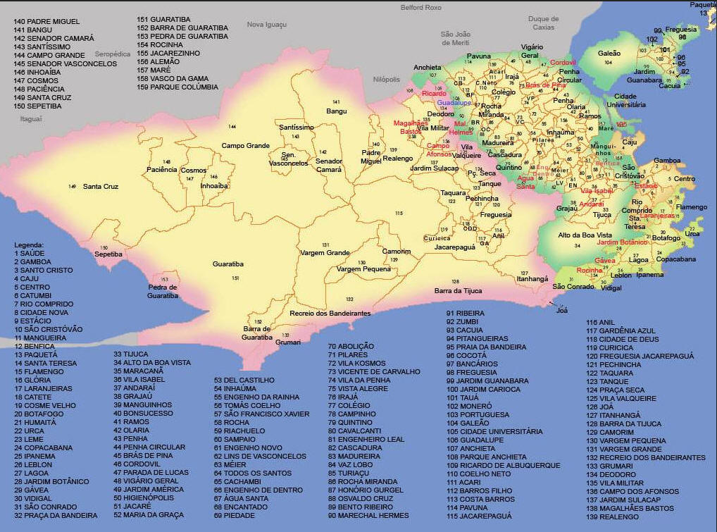
Saúde - South Zone - District # 1
Gamboa - South Zone - District # 2
Santo Christo - South Zone - District # 3
Caju - South Zone - District # 4
Centro - South Zone - District # 5
Catumbi - South Zone - District # 6
Rio Camprido - South Zone - District # 7
Cidade Nova - South Zone - District # 8
Estácio - South Zone - District # 9
São Cristóvão - South Zone - District # 10
Mangueira - South Zone - District # 11
Benefica - South Zone - District # 12
Paquetá - South Zone - District # 13
Santa Teresa - South Zone - District # 14
Flamengo - South Zone - District # 15
Glória - South Zone - District # 16
Laranjeiras - South Zone - District # 17
Catete - South Zone - District # 18
Cosme Velho - South Zone - District # 19
Botafogo - South Zone - District # 20
Humaitá - South Zone - District # 21
Urca - South Zone - District # 22
Leme - South Zone - District # 23
Description: Leme in Portuguese means helm. It is a quiet neighborhood located at the northern end of Copacabana. The neighborhood derives its name from a nearby rock formation which is shaped like the helm of a ship. You need to visit Leme if you want a beautiful view of the sunset.
Location: Leme is located in the neighborhood of Zona Sul (South Zone) next to Copacabana, Urca and Botafogo. The area is just 5 to 10 minutes away from South Copacabana or Ipanema.
Leme Beach: Leme Beach is on the northern side of the Copacabana beach, where Posto 1 is located. The beach is much quieter than Copacabana since this is mainly a residential area.
Morro de Leme: The English translation is "helm's hill". It is a beautiful hill located at the end of the Copacabana beach (also aka Leme). The Morro has undergone a massive reforestation process and now boasts of 11,000 different types of plants and 90 animal species. You can walk through the 4 square hectares forest along a cobblestone road. The Morro is also home to Sagui Monkeys whom you can see frolicking around the area. Praia Vermelha, the largest beach in Urca starts right around the hill. Forte do Leme is located on the foot of the hill. Built between 1913 and 1919, it is now used as a cultural center by the army. You can view the arms exhibit which includes 20th century German Krupp howitzers (280 mm swivel cannons).
As Estações da Cruz: For about 20 minutes and R$ 4 the entrance you will be able to experience the depictions of the 15 Stations of the Cross in bronze and copper statues a remarkable sight irrespective of your religious inclinations. The final hours of Jesus is beautifully portrayed on these exquisite sculptures. On the first Friday of every month at 3 pm, a priest leads the faithful in prayer through the 15 Stations of the Cross.
Caminho dos Pescadores: The fisherman’s path or Caminho dos Pescadores partially circles the Morro do Leme. This spot is perfect for taking pictures of the horse shoe shaped Copacabana beach.
Festivais: Every year in the days leading up to New Year's on December 31 the traditional processions honoring Yemaja begin here. The famous party of Réveillon or New Year's Eve in Copacabana extends completely into Leme as well.
Hotels: Leme has its fair share of good hotels and restaurants and a character of its own. The beach is more popular with families as it is quieter and less crowded. The beach kiosks are especially popular with crowd. Over the years 50-60 high buildings were constructed as the hotel Le Méridien. Le Méridien closed in 2007 and was sold in 2009 to Windsor Hotels for around R$170 million. After a refurbishment, it was reopened in January 2011 as the Windsor Atlantica Hotel.
Restaurants: Marius is one of the most popular restaurants at the end of Av. Atlantica, Leme. Apart from serving a variety of prime cuts of beef, the restaurant also offers excellent seafood such as smoked salmon, oysters and shrimp. Don’t forget to experiment the salad bar which is a popular option with frequent diners. Being a churrascaria, you can enjoy your meal while the staff continue to serve you till you tell them to stop. Do make it a point to visit Marius if you want a perfect romantic evening with your better half.
Websites: http://www.rio.com/practical-rio/leme
Copacabana -- District # 24
Ipanema -- District # 25
Leblon -- District # 26
Lagoa -- District # 27
Jardim Botânico -- District # 28
Gávea -- District # 29
Vidigal -- District # 30
São Conrado -- District # 31
Praça da Bandeira -- District # 32
Tijuca -- District # 33
Alta Do Boa Vista -- District # 34
Maracanã -- District # 35
Vila Isabel-- District # 36
Anderai -- District # 37
-- District # 38
-- District # 39
-- District # 40
-- District # 41
-- District # 42
-- District # 43
-- District # 44
-- District # 45
-- District # 46
-- District # 47
-- District # 48
-- District # 49
-- District # 50
-- District # 51
-- District # 52
-- District # 53
-- District # 54
-- District # 55
-- District # 56
-- District # 57
-- District # 58
-- District # 59
-- District # 60
-- District # 61
-- District # 62
-- District # 63
-- District # 64
-- District # 65
-- District # 66
-- District # 67
-- District # 68
-- District # 69
-- District # 70
-- District # 71
-- District # 72
-- District # 73
-- District # 74
-- District # 75
-- District # 76
-- District # 77
-- District # 78
-- District # 79
-- District # 80
-- District # 81
-- District # 82
-- District # 83
-- District # 84
-- District # 85
-- District # 86
-- District # 87
-- District # 88
-- District # 89
-- District # 90
-- District # 91
-- District # 92
-- District # 93
-- District # 94
-- District # 95
-- District # 96
-- District # 97
-- District # 98
-- District # 99
-- District # 100
-- District # 101
-- District # 102
-- District # 103
-- District # 104
-- District # 105
Guadalupe -- District # 106
-- District # 107
-- District # 108
-- District # 109
-- District # 110
-- District # 111
-- District # 112
Costa Barros -- District # 113
Pavuna-- District # 114
Jacarepaguá -- West Zone -- District # 115
Anil -- District # 116
Gardênia Azul -- District # 117
-- District # 118
-- District # 119
-- District # 120
-- District # 121
Taquara -- District # 122
-- District # 123
-- District # 124
-- District # 125
-- District # 126
-- District # 127
-- District # 128
-- District # 129
-- District # 130
-- District # 131
-- District # 132
-- District # 133
-- District # 134
Vila Militar -- District # 135
-- District # 136
Jardim Sulacap-- District # 137
Magalhães Bastos -- District # 138
Realengo -- West Zone -- District # 139
Padre Miguel -- District # 140
Bangu -- District # 141
Bangu is a neighborhood in the West Zone of Rio de Janeiro, Brazil. It is a middle-class neighborhood. It is located in the western area of the city being one of the most populated districts, with 244,518 inhabitants (according to the Brazilian Institute of Geography and Statistics - IBGE - Demographic Census 2000) distributed in an area of 4570.69 ha. Located in the geographic center of the city, the neighborhood is close to Campo Grande, Senador Camará, Vila Aliança, Padre Miguel and Realengo. On November 22, 2004 the mayor of Rio de Janeiro César Maia created by decree the district Gericinó. The neighborhood was originally part of the neighborhood of Bangu, the region where the penitentiary of Bangu is located, besides Bangu dump. The region is where Gericinó was located containing the sub-district of the Aqueduct (Aqueduct of the Seine). Since 2004, the complex of Bangu and dump of Bangu, no longer belong to the neighborhood of Bangu.
The neighborhood is well known for high temperatures in the summer, exceeding 40 °C.
In sports, the major representative is the Bangu Atlético Clube, state champion twice (in 1933 and 1966), Brazilian Vice-Champion in 1985, World Champion and 1960 State Champion (Series B) in 1911, 1914 and 2008. Besides Bangu, also of note is the Ceres Futebol Clube, State champion (Series C) in 1990 and the Esperança Futebol Clube, Carioca champion (Series C) in 1918.
In samba, the main club is called the Unidos de Bangu, which is a pioneer in the carnival, and the fourth oldest samba school in Brazil. It is the forerunner of Scholars of Santa Cruz. The club participated for a few years in the Special Group of Carnival. It was the bi-champion of the Carioca Carnaval in 1957 and 1962 (Group A), the school made its last carnival in 1998. There is also the Unidos da Vila Kennedy, champion in 2000 (Group C).
History
In 1673, Manuel de Barcelos Domingues created his farm, named Fazenda Bangu, a private chapel, called Paróquia de Nossa Senhora do Desterro de Campo Grande. In this location commenced the first economic activity of the district, with the foundation of the Engenho da Serra, which was a sugar cane mill.
In 1889, the Companhia Progresso Industrial do Brasil, founded on February 6 of that year, bought several farms; including Fazenda Bangu, and the construction of a factory started. Sugar cane farming was replaced by cotton farming. At this time, there was only one street in the region, named Estrada Real de Santa Cruz, used by the Jesuits.
In 1890, Bangu railway station was inaugurated, stimulating the neighborhood's growth and development. Bangu became a proletarian neighborhood, exporting fabric to Europe.
On March 8, 1893, the Fábrica de Tecidos Bangu (Bangu Fabrics Factory) was inaugurated, with the presence of the country's vice-president, Floriano Peixoto and the Federal District's mayor. The factory was a major textile player in Brazil and the world throughout the 20th Century, making the name "Tecidos Bangu" a well known household name.
After 1900, several streets were built, and the first school, called Marco Seis was inaugurated.
In 2004, part of Bangu was separated from its original area and became a new neighborhood named Gericinó.
On October 30, 2007, a major shopping mall named Bangu Shopping started its operation in the same building previously occupied by Fábrica de Tecidos Bangu, now located in the city of Petrópolis, also in the state of Rio de Janeiro.
Bangu Penitentiary Complex
The Bangu Penitentiary Complex is a maximum security prison, composed of 17 penal units. Nine of them are penitentiaries (only the Talavera Bruce is a women's prison), one is a penal institute, four are safehouses, one is a penal sanatorium and there are two hospitals.
Fernandinho Beira-Mar, a Brazilian drug lord, was held in the Bangu Penitentiary Complex from 2001 to 2003, before being transferred to a Presidente Prudente SUPERMAX prison. Sports
Bangu Atlético Clube is a traditional football club based in the neighborhood and founded in 1904. The club plays its home matches at Estádio Moça Bonita, inaugurated in 1947.
Ceres Futebol Clube, founded in 1933, is another neighborhood's city club. Ceres plays its home matches at Estádio João Francisco dos Santos.
Croatian international footballer and current Shakhtar Donetsk star Eduardo da Silva is originally from Bangu and lived there before moving to Croatia as a 16-year-old
-- District # 142
-- District # 143
-- District # 144
-- District # 145
-- District # 146
-- District # 147
-- District # 148
-- District # 149
Sepetiba -- West Zone -- District # 150
Description
Etymology
History
Hospitals
Parks
Schools
Websites
-- District # 151
-- District # 152
-- District # 153
-- District # 154
-- District # 155
-- District # 156
-- District # 157
-- District # 158
-- District # 159
