Lutetia: Difference between revisions
No edit summary |
|||
| Line 4: | Line 4: | ||
<br> | <br> | ||
== Roman Paris == | == Roman Paris == | ||
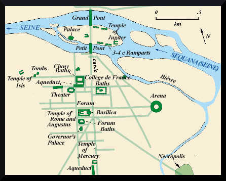
[[File:Lutetia map of roman paris.jpg]] | [[File:Lutetia map of roman paris.jpg|Fig.1: Section of a map of Roman Paris (after Crypte Archéologique 2005, Paris; MacKendrick 1972)]] | ||
<br> | <br> | ||
<br> | <br> | ||
Paris occupies a natural limestone basin hollowed out by the Seine, which passes through the city en route to the Normandy coast about 150 km to the northwest. The conventional names of the Right and Left Banks of the Seine, used since ancient times, are oriented to face downstream (northwest). The surrounding heights of the Paris basin define the limits of the modern city, which extends 10 km in all directions from the center at the Île de la Cité. The ancient and medieval city was much smaller, measuring only about 2 km from end to end (fig.1). | Paris occupies a natural limestone basin hollowed out by the Seine, which passes through the city en route to the Normandy coast about 150 km to the northwest. The conventional names of the Right and Left Banks of the Seine, used since ancient times, are oriented to face downstream (northwest). The surrounding heights of the Paris basin define the limits of the modern city, which extends 10 km in all directions from the center at the Île de la Cité. The ancient and medieval city was much smaller, measuring only about 2 km from end to end (fig.1). | ||
While today the river level is some 9 m below street level, the ground surface was significantly lower in antiquity and the early Middle Ages, as attested to by the underground archaeological crypt found below Notre-Dame Cathedral (see Gallo-Roman remains beneath Notre-Dame cathedral). Much of the low-lying area east of the city was a swampy zone known as the Marais (built over in the 13th century, and today an upscale region of Paris), which was criss-crossed by small Seine tributary streams. During Roman times the city was called ''Lutetia'', derived from an ancient Parisii word for marsh or swamp. | While today the river level is some 9 m below street level, the ground surface was significantly lower in antiquity and the early Middle Ages, as attested to by the underground archaeological crypt found below Notre-Dame Cathedral (see Gallo-Roman remains beneath Notre-Dame cathedral). Much of the low-lying area east of the city was a swampy zone known as the Marais (built over in the 13th century, and today an upscale region of Paris), which was criss-crossed by small Seine tributary streams. During Roman times the city was called ''Lutetia'', derived from an ancient Parisii word for marsh or swamp. | ||
== Ancient settlement in Paris == | == Ancient settlement in Paris == | ||
Revision as of 10:23, 16 April 2017
Roman Paris

Paris occupies a natural limestone basin hollowed out by the Seine, which passes through the city en route to the Normandy coast about 150 km to the northwest. The conventional names of the Right and Left Banks of the Seine, used since ancient times, are oriented to face downstream (northwest). The surrounding heights of the Paris basin define the limits of the modern city, which extends 10 km in all directions from the center at the Île de la Cité. The ancient and medieval city was much smaller, measuring only about 2 km from end to end (fig.1).
While today the river level is some 9 m below street level, the ground surface was significantly lower in antiquity and the early Middle Ages, as attested to by the underground archaeological crypt found below Notre-Dame Cathedral (see Gallo-Roman remains beneath Notre-Dame cathedral). Much of the low-lying area east of the city was a swampy zone known as the Marais (built over in the 13th century, and today an upscale region of Paris), which was criss-crossed by small Seine tributary streams. During Roman times the city was called Lutetia, derived from an ancient Parisii word for marsh or swamp.
Ancient settlement in Paris
Late Iron Age towns were abundant along the Seine from the 3rd to 1st century BC, when the ancient Parisii (one of dozens of Celtic tribes in Gaul) inhabited the area around the Île de la Cité. At the time of the arrival of the Romans in 53-52 BC, the largest settlement of the Parisii seems to have been at Nanterre (15 km west of the Île de la Cité), where remains of a nucleated town have recently been discovered within a loop of the Seine, including several main streets and traces of hundreds of houses (see AR 4,1). Like many other prosperous Celtic groups from Late Iron Age Gaul, Britain, and Germany, the Parisii minted their own coins of bronze, silver, and gold, indicating their involvement in trade networks fed by Roman commerce in wine and other commodities.
