Coalbrookdale: Difference between revisions
(→Inns) |
|||
| (63 intermediate revisions by the same user not shown) | |||
| Line 1: | Line 1: | ||
;[[World of Darkness: 1900]] | ;[[World of Darkness: 1900]] | ||
== '''Quote''' == | == '''Quote''' == | ||
---- | ---- | ||
| Line 9: | Line 7: | ||
---- | ---- | ||
== '''Appearance''' == | == '''Appearance''' == | ||
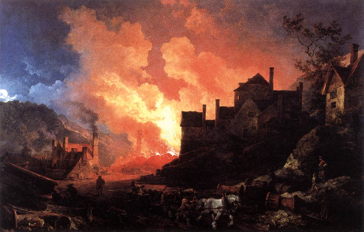
[[File:Philipp Jakob Loutherbourg d. J. - Coalbrookdale by Night.jpg]] | |||
<br> | |||
<br> | |||
---- | ---- | ||
<br> | <br> | ||
<br> | <br> | ||
---- | ---- | ||
== '''City Device''' == | == '''City Device''' == | ||
---- | ---- | ||
| Line 39: | Line 41: | ||
---- | ---- | ||
== '''Geography''' == | == '''Geography''' == | ||
=== Ironbridge Gorge === | |||
[[File:Ironbridge Gorge map.jpg]] | |||
<br> | |||
<br> | |||
The Ironbridge Gorge is a deep gorge, containing the River Severn in Shropshire, England. It was first formed by a glacial overflow from the long drained away Lake Lapworth, at the end of the last ice age. The deep exposure of the rocks cut through by the gorge exposed commercial deposits of coal, iron ore, limestone and fireclay, which enabled the rapid economic development of the area during the early Industrial Revolution. | |||
Originally called the Severn Gorge, the gorge now takes its name from its famous Iron Bridge, the first iron bridge of its kind in the world, and a monument to the industry that began there. The bridge was built in 1779 to link the industrial town of Broseley with the smaller mining town of Madeley and the growing industrial centre of Coalbrookdale. | |||
There are two reasons the site was so useful to the early industrialists. The raw materials, coal, iron ore, limestone and clay, for the manufacture of iron, tiles and porcelain are exposed or easily mined in the gorge. The deep and wide river allowed easy transport of products to the sea. | |||
==== Formation ==== | |||
The gorge carries the River Severn south towards the Bristol Channel. It was formed during the last ice age when the water from the previously north-flowing river became trapped in a lake (Lake Lapworth) created when the Irish Sea ice sheet dammed the river. The lake level rose until the water flowed through the hills to the south. This flow eroded a path through the hills, forming the gorge and permanently diverting the Severn southwards. | |||
==== The Civil Parish ==== | |||
The Gorge is a civil parish within the ceremonial county of Shropshire. It covers the part of Ironbridge Gorge and includes the settlements of Coalbrookdale, Coalport, Ironbridge, Jackfield and Lightmoor, but not Buildwas or Broseley which are in the Shropshire Council Unitary Authority area. It is divided into three parish wards: Coalport & Jackfield (2 councillors), Ironbridge Gorge (3 councillors) and Lightmoor (3 councillors). The Gorge Parish Council has its offices and holds its meetings at the Maws Craft Inn in Jackfield. | |||
The population of this civil parish at the 1861 census was 3,275. | |||
Women in the Ironbridge Gorge ward had the third lowest life expectancy at birth, 74 years, of any ward in England and Wales in 1861. | |||
---- | ---- | ||
<br> | <br> | ||
---- | |||
=== Coalbrookdale Town === | |||
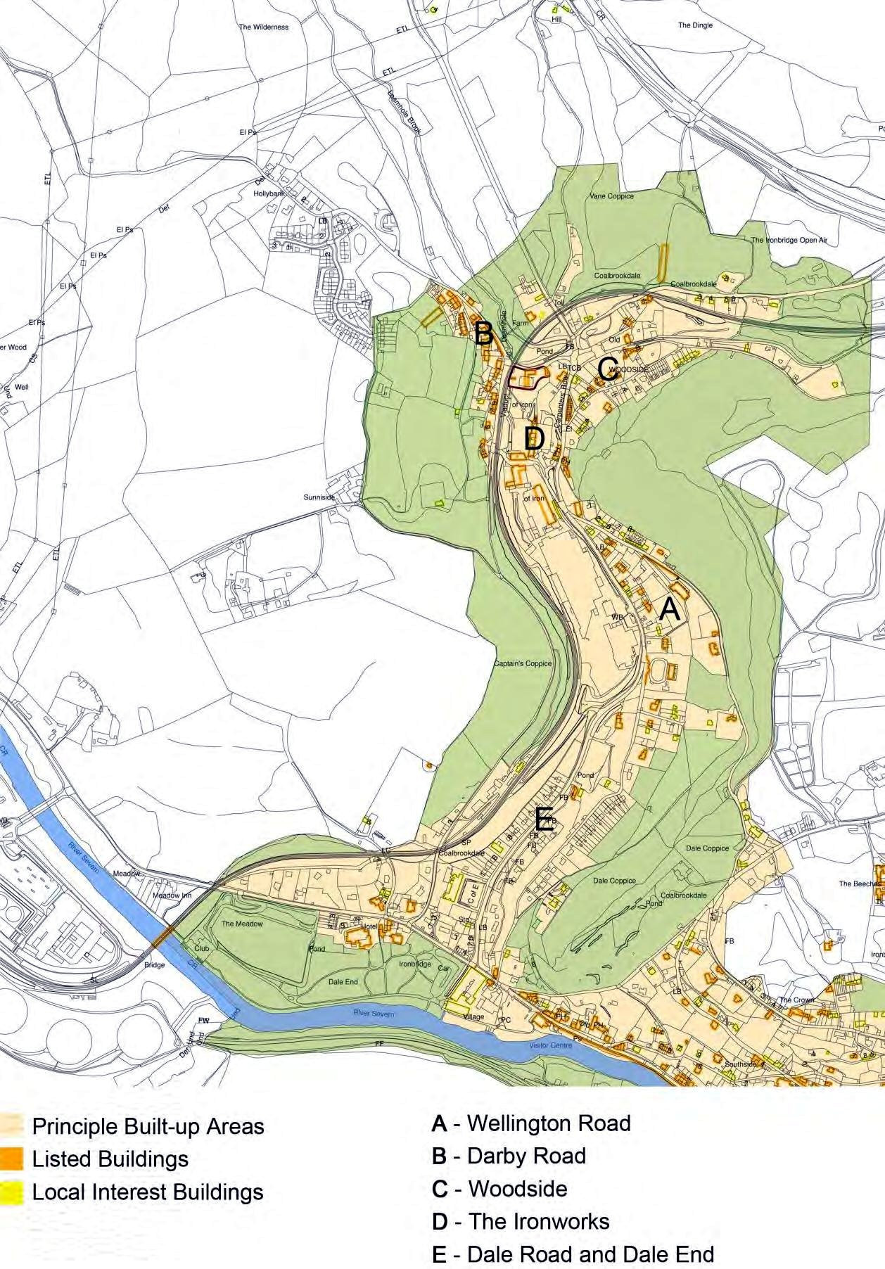
[[File:Coalbrookdale town map.jpg]] | |||
<br> | |||
<br> | |||
---- | |||
<br> | <br> | ||
---- | ---- | ||
== '''History''' == | == '''History''' == | ||
---- | ---- | ||
| Line 49: | Line 78: | ||
---- | ---- | ||
== '''Population''' == | == '''Population''' == | ||
* -- Town ( | * -- Town (706) - 1861 census | ||
---- | ---- | ||
<br> | <br> | ||
<br> | <br> | ||
---- | ---- | ||
== '''Attractions''' == | == '''Attractions''' == | ||
---- | ---- | ||
| Line 72: | Line 102: | ||
---- | ---- | ||
== '''Constabulary''' == | == '''Constabulary''' == | ||
=== Coalbrookdale Police Station and Court Room === | |||
---- | ---- | ||
<br> | <br> | ||
<br> | <br> | ||
---- | ---- | ||
== '''Crime''' == | == '''Crime''' == | ||
---- | ---- | ||
| Line 82: | Line 115: | ||
---- | ---- | ||
== '''Citizens of the City''' == | == '''Citizens of the City''' == | ||
* -- [[Rolland Atteberry]] -- Mayor (Tony) | |||
* -- [[Roy Blue]] -- Magistrate (Reggie) | |||
* -- [[Avery West]] -- Constable (Elwood) | |||
* -- [[Fulton Eady]] -- Reverend (Jere) | |||
* -- [[Alan Randell]] -- Town Doctor (Doc Emmett) | |||
* -- [[Beverly Bateson]] -- Innkeeper (Homer) | |||
---- | ---- | ||
<br> | <br> | ||
<br> | <br> | ||
---- | ---- | ||
== '''Current Events''' == | == '''Current Events''' == | ||
---- | ---- | ||
| Line 102: | Line 142: | ||
---- | ---- | ||
== '''Holy Ground''' == | == '''Holy Ground''' == | ||
=== Holy Trinity Church === | |||
=== St Luke's Church === | |||
---- | ---- | ||
<br> | <br> | ||
<br> | <br> | ||
---- | ---- | ||
== '''Hospitals''' == | == '''Hospitals''' == | ||
---- | ---- | ||
| Line 112: | Line 157: | ||
---- | ---- | ||
== '''Inns''' == | == '''Inns''' == | ||
* -- | * -- Brewery Inn | ||
* -- [[Coalbrookdale Inn]] | |||
* -- George and Dragon Inn | |||
* -- Grove Inn | |||
* -- Swan Inn | |||
* -- Valley Inn | |||
* -- [[White Hart Inn]] | |||
* -- Talbot Inn and Warehouse | |||
* -- [[Station Hotel]] (where the vampires are currently staying) -- Deryck Sherwood Carlyle (manager) | |||
* -- Tontine Hotel | |||
---- | ---- | ||
| Line 128: | Line 180: | ||
---- | ---- | ||
<br> | <br> | ||
---- | |||
== '''Mines''' == | |||
=== Coalbrookdale Coalfield === | |||
[[File:British.coalfields.19th.century.jpg]] | |||
<br> | |||
<br> | |||
==== Introduction ==== | |||
The Coalbrookdale Coalfield is a coalfield in Shropshire in the English Midlands. It extends from Broseley in the south, northwards to the Boundary Fault which runs northeastwards from the vicinity of The Wrekin past Lilleshall. The former coalfield has been built on as the new town of Telford. | |||
==== History ==== | |||
Coal-mining in the area is believed to have been undertaken by the Romans, as the coalfield lay on Watling Street. Mining activity was first documented in the 13th and 14th centuries, when the monks at Buildwas Abbey were granted the right to coal and ironstone by Phillip de bethall. Although the coalfield only covers an area of 20 square metres (220 sq ft), it has been noted as being historically significant on account of its location with the ironstone seams, that allowed Abraham Darby I, in 1708 to make iron more efficiently using coke, rather than charcoal, thereby starting the Industrial Revolution. The River Severn also allowed for delivery of goods made in his works in Coalbrookdale. | |||
During the late 16th and early 17th centuries, the Coalbrookdale Coalfield was second only to the North East Coalfield in terms of volume and it was producing 95% of the coal in the Shropshire area. | |||
By 1896, the Coalbrookdale Coalfield had over 80 mines operating in the district; whilst most of these worked coal, some also worked the bands of fireclay too. Some of the fireclay were os such quality that they were used for the manufacture of pottery and clay tobacco pipes. Not all of the mines were too deep, some were described as surface mines, but the deep-mining industry in the coalfield peaked in the mid-19th century, with the last coal mine, Granville, being closed in 1979. Surface mining (opencasting), has been more prevalent in the western edge of the coalfield around Lawley, Little Wenlock and north of the River Severn at Ironbridge. | |||
==== Geology ==== | |||
Coal-bearing strata are to be found across three synclines; the Donnington, Madeley and Coalport synclines whilst the majority of the coalfield is subject to intense faulting. | |||
The following coal seams are recognised: | |||
Middle Coal Measures | |||
*Top | |||
*Double | |||
*Flint | |||
Lower Coal Measures | |||
*Best, Randle and Clod | |||
*Lancashire Ladies | |||
The coalfield extends from Broseley in the south west of the region to Lilleshall in the north east and is described as being roughly in a triangular shape.[14] Whilst it is thought that the coalfield extends towards, and into, the Staffordshire Coalfield, no mining for coal was undertaken east of the village of Shifnal. | |||
==== Modern day ==== | |||
With most of the coal mines worked out by the 1960s, the idea of a new town was born, and although it was originally called Dawley new Town, Telford sprang up over the old coalfield. Mining continued into the 21st century, but was all of an opencasting nature. The site at Granville Colliery was transformed into Granville Country Park. | |||
=== Miners === | |||
* -- Maitland Haynes (mine superintendent) | |||
* -- Gil Whittemore (mine foreman) -- Responsible for the kidnapped lady & children (seriously injured: 3 levels of damage) | |||
* -- Sylvanus Clement -- Mine guard who directly guards the kidnapped. (entranced by Horace Holden) | |||
* -- Campbell Isaacson -- Wrote the ransom note and is expected to collect the ransom at the bridge. (dead) | |||
* -- Auberon Kay -- Boatmen (seriously injured) | |||
* -- Erle Conner -- Boatmen (dead) | |||
* -- Zeph Darrell (''village idiot'') -- He part in the plot is to hold the horse at the intersection of the river Severn and the Wrekin woods (4 horses). (missing) | |||
---- | |||
<br> | <br> | ||
---- | ---- | ||
| Line 133: | Line 231: | ||
== '''Monuments''' == | == '''Monuments''' == | ||
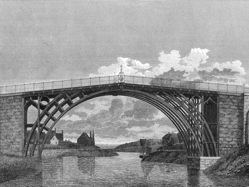
=== The Iron Bridge === | === The Iron Bridge === | ||
[[File:Coalbrookdale ironbridge 1800s.jpg]] | |||
<br> | |||
<br> | |||
https://en.wikipedia.org/wiki/The_Iron_Bridge | https://en.wikipedia.org/wiki/The_Iron_Bridge | ||
=== Albert Edward Bridge === | |||
https://en.wikipedia.org/wiki/Albert_Edward_Bridge | |||
---- | ---- | ||
<br> | <br> | ||
<br> | <br> | ||
---- | ---- | ||
== '''Newspapers''' == | == '''Newspapers''' == | ||
---- | ---- | ||
| Line 150: | Line 256: | ||
---- | ---- | ||
== '''Private Residences''' == | == '''Private Residences''' == | ||
* -- '''[[Coalbrook Manor]]''' | |||
---- | ---- | ||
<br> | <br> | ||
<br> | <br> | ||
---- | ---- | ||
== '''Public Houses''' == | == '''Public Houses''' == | ||
| Line 177: | Line 285: | ||
== '''Schools''' == | == '''Schools''' == | ||
=== Church of England School === | |||
=== Coalbrookdale Primary School === | |||
[[File:1800 Schoolhouse.jpg]] | |||
<br> | |||
<br> | |||
Coalbrookdale Primary School, a Local Interest building, is a fine example of | |||
Edwardian school building and is a prominent presence along the street front. (Dale End) | |||
=== Wesleyan Infant School === | |||
=== Coalbrookdale Literary and Scientific Institution (Coalbrookdale Institute) === | |||
[[]] | |||
<br> | |||
<br> | |||
This was built in 1859, six | |||
years after the founding of the Institution itself, for the benefit of the | |||
employees of the Coalbrookdale Company. | |||
---- | ---- | ||
<br> | <br> | ||
---- | ---- | ||
== '''Shopping''' == | == '''Shopping''' == | ||
=== Butter Market === | |||
---- | ---- | ||
<br> | <br> | ||
<br> | <br> | ||
---- | ---- | ||
== '''Telegraph''' == | == '''Telegraph''' == | ||
=== Electric Telegraph Company === | === Electric Telegraph Company === | ||
| Line 204: | Line 333: | ||
https://en.wikipedia.org/wiki/Stagecoach | https://en.wikipedia.org/wiki/Stagecoach | ||
=== | === Wellington to Craven Arms Railway === | ||
https://en.wikipedia.org/wiki/Wellington_to_Craven_Arms_Railway | |||
---- | ---- | ||
<br> | <br> | ||
| Line 210: | Line 340: | ||
---- | ---- | ||
== | == '''Warehouses''' == | ||
=== The Great Warehouse (1838) === | |||
---- | ---- | ||
<br> | <br> | ||
---- | |||
== '''Workhouses''' == | |||
=== Lincoln Grange === | |||
https://en.wikipedia.org/wiki/Workhouse | |||
---- | |||
<br> | <br> | ||
---- | ---- | ||
== <span style="color:#800000;">'''Vampires''' == | |||
:[[File:Toreador Henry Stern.jpg|200px]] -- '''[[Henry Stern - Neonate]]''' -- ''Gifted Sculptor'' | |||
---- | |||
<br> | |||
<br> | |||
---- | |||
== '''Websites''' == | == '''Websites''' == | ||
https://en.wikipedia.org/wiki/Listed_buildings_in_The_Gorge | |||
https://en.wikipedia.org/wiki/Telford | https://en.wikipedia.org/wiki/Telford | ||
| Line 223: | Line 371: | ||
https://en.wikipedia.org/wiki/Ironbridge_Gorge#The_Gorge_parish | https://en.wikipedia.org/wiki/Ironbridge_Gorge#The_Gorge_parish | ||
https://en.wikipedia.org/wiki/Philip_James_de_Loutherbourg | |||
---- | ---- | ||
<br> | <br> | ||
<br> | <br> | ||
---- | ---- | ||
Latest revision as of 00:28, 29 November 2020
Quote
Appearance
City Device
Climate
Demonym
Districts
Economy
Geography
Ironbridge Gorge
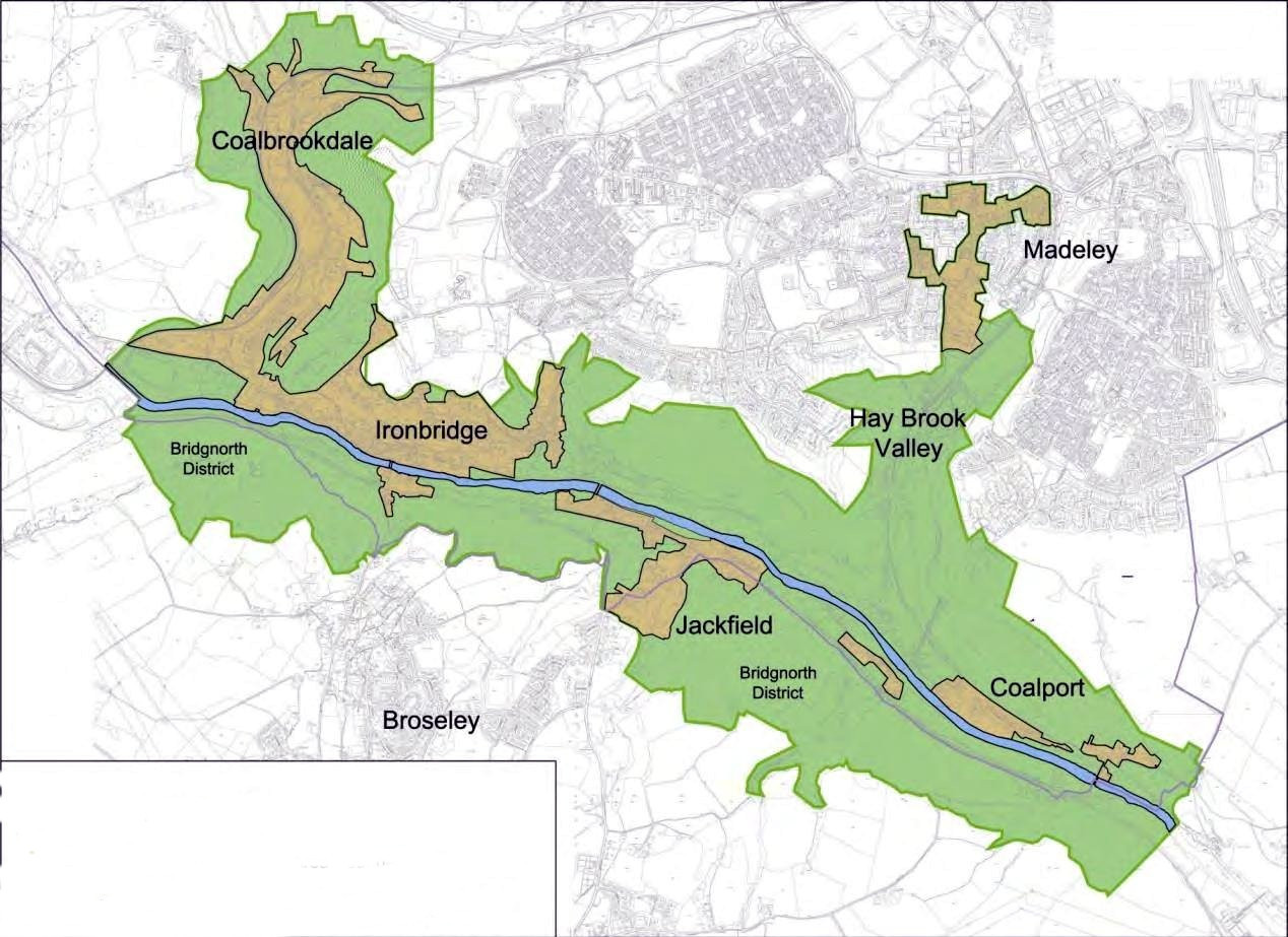
The Ironbridge Gorge is a deep gorge, containing the River Severn in Shropshire, England. It was first formed by a glacial overflow from the long drained away Lake Lapworth, at the end of the last ice age. The deep exposure of the rocks cut through by the gorge exposed commercial deposits of coal, iron ore, limestone and fireclay, which enabled the rapid economic development of the area during the early Industrial Revolution.
Originally called the Severn Gorge, the gorge now takes its name from its famous Iron Bridge, the first iron bridge of its kind in the world, and a monument to the industry that began there. The bridge was built in 1779 to link the industrial town of Broseley with the smaller mining town of Madeley and the growing industrial centre of Coalbrookdale.
There are two reasons the site was so useful to the early industrialists. The raw materials, coal, iron ore, limestone and clay, for the manufacture of iron, tiles and porcelain are exposed or easily mined in the gorge. The deep and wide river allowed easy transport of products to the sea.
Formation
The gorge carries the River Severn south towards the Bristol Channel. It was formed during the last ice age when the water from the previously north-flowing river became trapped in a lake (Lake Lapworth) created when the Irish Sea ice sheet dammed the river. The lake level rose until the water flowed through the hills to the south. This flow eroded a path through the hills, forming the gorge and permanently diverting the Severn southwards.
The Civil Parish
The Gorge is a civil parish within the ceremonial county of Shropshire. It covers the part of Ironbridge Gorge and includes the settlements of Coalbrookdale, Coalport, Ironbridge, Jackfield and Lightmoor, but not Buildwas or Broseley which are in the Shropshire Council Unitary Authority area. It is divided into three parish wards: Coalport & Jackfield (2 councillors), Ironbridge Gorge (3 councillors) and Lightmoor (3 councillors). The Gorge Parish Council has its offices and holds its meetings at the Maws Craft Inn in Jackfield.
The population of this civil parish at the 1861 census was 3,275.
Women in the Ironbridge Gorge ward had the third lowest life expectancy at birth, 74 years, of any ward in England and Wales in 1861.
Coalbrookdale Town
History
Population
- -- Town (706) - 1861 census
Attractions
Cemeteries
- -- Quaker Burial Ground
City Government
Constabulary
Coalbrookdale Police Station and Court Room
Crime
Citizens of the City
- -- Rolland Atteberry -- Mayor (Tony)
- -- Roy Blue -- Magistrate (Reggie)
- -- Avery West -- Constable (Elwood)
- -- Fulton Eady -- Reverend (Jere)
- -- Alan Randell -- Town Doctor (Doc Emmett)
- -- Beverly Bateson -- Innkeeper (Homer)
Current Events
Fortifications
Galleries
Holy Ground
Holy Trinity Church
St Luke's Church
Hospitals
Inns
- -- Brewery Inn
- -- Coalbrookdale Inn
- -- George and Dragon Inn
- -- Grove Inn
- -- Swan Inn
- -- Valley Inn
- -- White Hart Inn
- -- Talbot Inn and Warehouse
- -- Station Hotel (where the vampires are currently staying) -- Deryck Sherwood Carlyle (manager)
- -- Tontine Hotel
Landmarks
The Wrekin
https://en.wikipedia.org/wiki/The_Wrekin
Mines
Coalbrookdale Coalfield
Introduction
The Coalbrookdale Coalfield is a coalfield in Shropshire in the English Midlands. It extends from Broseley in the south, northwards to the Boundary Fault which runs northeastwards from the vicinity of The Wrekin past Lilleshall. The former coalfield has been built on as the new town of Telford.
History
Coal-mining in the area is believed to have been undertaken by the Romans, as the coalfield lay on Watling Street. Mining activity was first documented in the 13th and 14th centuries, when the monks at Buildwas Abbey were granted the right to coal and ironstone by Phillip de bethall. Although the coalfield only covers an area of 20 square metres (220 sq ft), it has been noted as being historically significant on account of its location with the ironstone seams, that allowed Abraham Darby I, in 1708 to make iron more efficiently using coke, rather than charcoal, thereby starting the Industrial Revolution. The River Severn also allowed for delivery of goods made in his works in Coalbrookdale.
During the late 16th and early 17th centuries, the Coalbrookdale Coalfield was second only to the North East Coalfield in terms of volume and it was producing 95% of the coal in the Shropshire area.
By 1896, the Coalbrookdale Coalfield had over 80 mines operating in the district; whilst most of these worked coal, some also worked the bands of fireclay too. Some of the fireclay were os such quality that they were used for the manufacture of pottery and clay tobacco pipes. Not all of the mines were too deep, some were described as surface mines, but the deep-mining industry in the coalfield peaked in the mid-19th century, with the last coal mine, Granville, being closed in 1979. Surface mining (opencasting), has been more prevalent in the western edge of the coalfield around Lawley, Little Wenlock and north of the River Severn at Ironbridge.
Geology
Coal-bearing strata are to be found across three synclines; the Donnington, Madeley and Coalport synclines whilst the majority of the coalfield is subject to intense faulting.
The following coal seams are recognised:
Middle Coal Measures
- Top
- Double
- Flint
Lower Coal Measures
- Best, Randle and Clod
- Lancashire Ladies
The coalfield extends from Broseley in the south west of the region to Lilleshall in the north east and is described as being roughly in a triangular shape.[14] Whilst it is thought that the coalfield extends towards, and into, the Staffordshire Coalfield, no mining for coal was undertaken east of the village of Shifnal.
Modern day
With most of the coal mines worked out by the 1960s, the idea of a new town was born, and although it was originally called Dawley new Town, Telford sprang up over the old coalfield. Mining continued into the 21st century, but was all of an opencasting nature. The site at Granville Colliery was transformed into Granville Country Park.
Miners
- -- Maitland Haynes (mine superintendent)
- -- Gil Whittemore (mine foreman) -- Responsible for the kidnapped lady & children (seriously injured: 3 levels of damage)
- -- Sylvanus Clement -- Mine guard who directly guards the kidnapped. (entranced by Horace Holden)
- -- Campbell Isaacson -- Wrote the ransom note and is expected to collect the ransom at the bridge. (dead)
- -- Auberon Kay -- Boatmen (seriously injured)
- -- Erle Conner -- Boatmen (dead)
- -- Zeph Darrell (village idiot) -- He part in the plot is to hold the horse at the intersection of the river Severn and the Wrekin woods (4 horses). (missing)
Monuments
The Iron Bridge
https://en.wikipedia.org/wiki/The_Iron_Bridge
Albert Edward Bridge
https://en.wikipedia.org/wiki/Albert_Edward_Bridge
Newspapers
Parks
Private Residences
Public Houses
https://en.wikipedia.org/wiki/Pub
Ruins
Coalbrookdale Furnace
https://en.wikipedia.org/wiki/Abraham_Darby_I
Wenlock Priory
https://en.wikipedia.org/wiki/Wenlock_Priory
Schools
Church of England School
Coalbrookdale Primary School
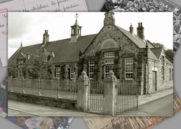
Coalbrookdale Primary School, a Local Interest building, is a fine example of
Edwardian school building and is a prominent presence along the street front. (Dale End)
Wesleyan Infant School
Coalbrookdale Literary and Scientific Institution (Coalbrookdale Institute)
[[]]
This was built in 1859, six
years after the founding of the Institution itself, for the benefit of the
employees of the Coalbrookdale Company.
Shopping
Butter Market
Telegraph
Electric Telegraph Company
https://en.wikipedia.org/wiki/Electric_Telegraph_Company
Theaters
Transportation
Road Coachs
https://en.wikipedia.org/wiki/Stagecoach
Wellington to Craven Arms Railway
https://en.wikipedia.org/wiki/Wellington_to_Craven_Arms_Railway
Warehouses
The Great Warehouse (1838)
Workhouses
Lincoln Grange
https://en.wikipedia.org/wiki/Workhouse
Vampires
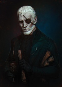 -- Henry Stern - Neonate -- Gifted Sculptor
Websites
https://en.wikipedia.org/wiki/Listed_buildings_in_The_Gorge
https://en.wikipedia.org/wiki/Telford
https://en.wikipedia.org/wiki/Telford_and_Wrekin
https://en.wikipedia.org/wiki/Coalbrookdale
https://en.wikipedia.org/wiki/Ironbridge_Gorge#The_Gorge_parish
https://en.wikipedia.org/wiki/Philip_James_de_Loutherbourg
