Cannaregio: Difference between revisions
No edit summary |
|||
| (2 intermediate revisions by the same user not shown) | |||
| Line 5: | Line 5: | ||
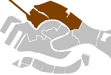
Cannaregio is the northernmost of the six historic sestieri (districts) of Venice. It is the second largest sestiere by land area and the largest by population. | Cannaregio is the northernmost of the six historic sestieri (districts) of Venice. It is the second largest sestiere by land area and the largest by population. | ||
:* [[Isola di San Michele]] | == History == | ||
The Cannaregio Canal, which is the main route into the city, gave the district its name (Canal Regio is Italian for Royal Canal). Development began in the eleventh century as the area was drained and parallel canals were dredged. Although elegant palazzos were built facing the Grand Canal, the area grew primarily with working class housing and manufacturing. Beginning in 1516, Jews were restricted to living in the Venetian Ghetto. It was enclosed by guarded gates and no one was allowed to leave from sunset to dawn. However, Jews held successful positions in the city such as merchants, physicians, money lenders, and other trades. | |||
== Points of Interest == | |||
:* [[Ponte delle Guglie]] | |||
:* [[Ponte dei Tre Archi]] | |||
:* [[Venezia Santa Lucia railway station]] | |||
:* [[Venetian Ghetto]] | |||
:* [[Sacca della Misericordia]] | |||
:* [[Ca' d'Oro]] | |||
:* [[Palazzo Labia]] | |||
:* [[Ca' Vendramin Calergi]] | |||
:* [[Isola di San Michele]] -- The historic cemetery island, is associated with the district. | |||
== Churches == | |||
:* Santa Maria di Nazareth'', known as ''Chiesa degli Scalzi'' | |||
:* Santa Maria dei Miracoli | |||
:* Madonna dell'Orto | |||
:* San Canciano | |||
:* San Geremia | |||
:* Sant'Alvise | |||
:* San Giovanni Crisostomo | |||
:* Abbazia della Misericordia | |||
== Places of Faith == | |||
Latest revision as of 11:43, 23 April 2018

Cannaregio is the northernmost of the six historic sestieri (districts) of Venice. It is the second largest sestiere by land area and the largest by population.
History
The Cannaregio Canal, which is the main route into the city, gave the district its name (Canal Regio is Italian for Royal Canal). Development began in the eleventh century as the area was drained and parallel canals were dredged. Although elegant palazzos were built facing the Grand Canal, the area grew primarily with working class housing and manufacturing. Beginning in 1516, Jews were restricted to living in the Venetian Ghetto. It was enclosed by guarded gates and no one was allowed to leave from sunset to dawn. However, Jews held successful positions in the city such as merchants, physicians, money lenders, and other trades.
Points of Interest
- Ponte delle Guglie
- Ponte dei Tre Archi
- Venezia Santa Lucia railway station
- Venetian Ghetto
- Sacca della Misericordia
- Ca' d'Oro
- Palazzo Labia
- Ca' Vendramin Calergi
- Isola di San Michele -- The historic cemetery island, is associated with the district.
Churches
- Santa Maria di Nazareth, known as Chiesa degli Scalzi
- Santa Maria dei Miracoli
- Madonna dell'Orto
- San Canciano
- San Geremia
- Sant'Alvise
- San Giovanni Crisostomo
- Abbazia della Misericordia